Travel report · Italy
Descent of the Tiber
380 kilometres alone by canoe, from Sansepolcro to the sea. Written for those who try it after me.
Translated from the German. Read the original Other translations: Español · Français · Italiano
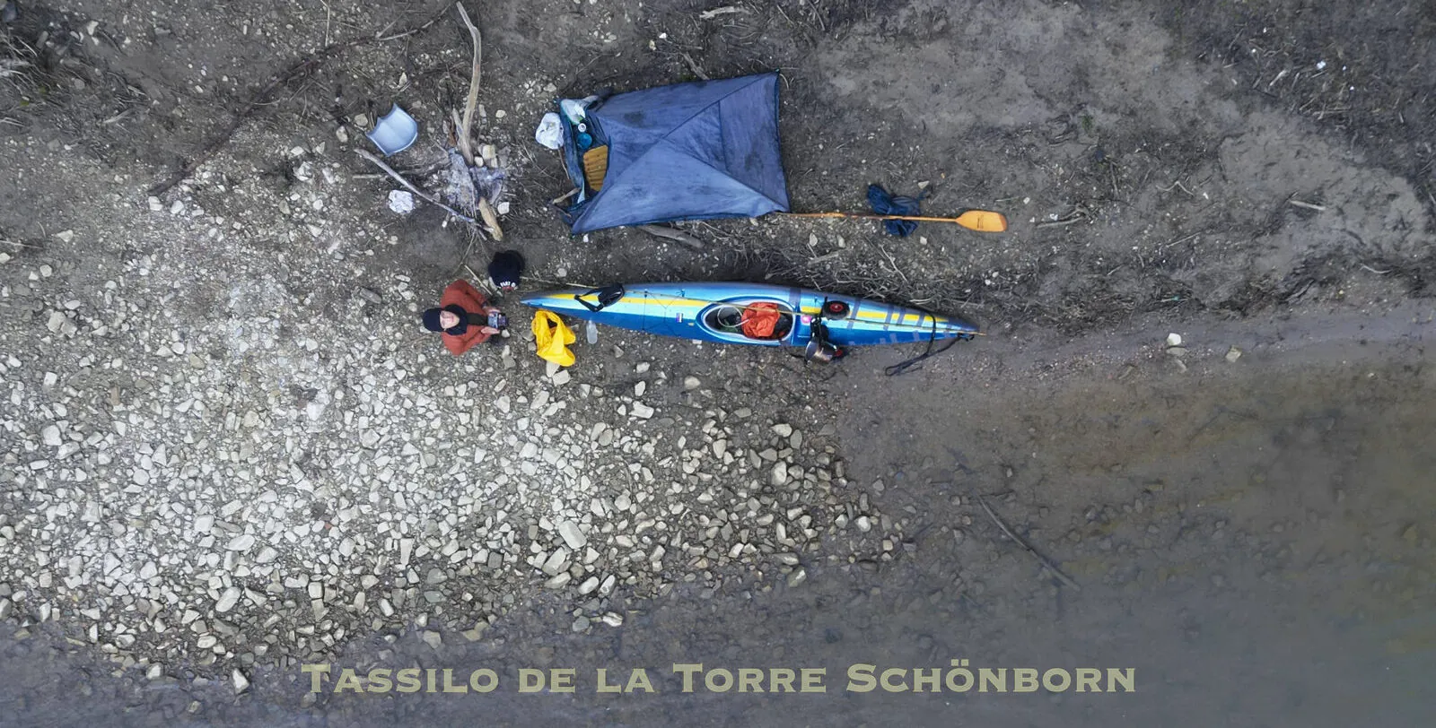
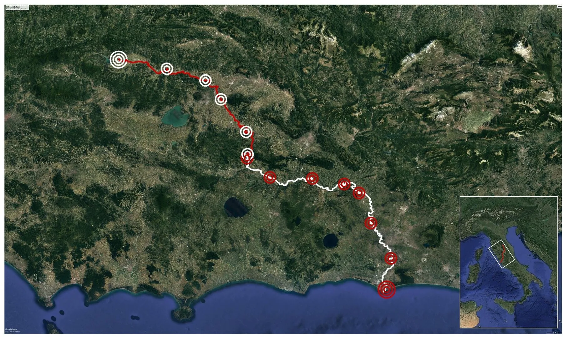
In the spring of 2023 I paddled the whole navigable length of the river Tiber alone by canoe. From Sansepolcro to the sea I spent a total of 12 days in the canoe to cover the 380 km.
A lot about the river was unclear to me. I found no travel reports about the whole river, nobody had paddled the whole stretch and documented it. The 380 kilometres I wanted to paddle were therefore full of places where I hardly knew what was coming.
I found one report, by chance in German, that roughly described the first 140 km. About the last 240 km I found almost nothing. This travel report is meant to give people who want to paddle the Tiber in future some picture of what lies ahead of them. I will try to give the most important information as precisely as possible, which will hopefully make planning the trip, and the trip itself, a little easier for someone.
In the interest of honesty: I was extremely badly equipped for this canoe trip, because for the sake of the environment and of money I did not want to buy anything. My clothes were a mix of ski, hiking and city clothes, mainly cotton, and absolutely not suited to a canoe trip. More importantly, the canoe: an ancient thing that I had bought from an 88 year old woman and that had already been through a lot. At first it held out bravely, but by the second day I had immense problems with leaks and in total I used up three rolls of tape. The many problems caused by the lack of proper gear certainly made the trip longer than it needed to be. In total I paddled for 12 days, 16 days including transport and travel, split into two stages. The plan to do it all in one go failed, because cold temperatures, a badly damaged canoe, missing gear and an accident did not allow it.
The river
The Tiber is the largest river in central Italy and meanders 405 km through Emilia-Romagna, Tuscany, Umbria and Lazio. The landscape changes a great deal along its course, from a small mountain river to a big, wide lowland river.
Some stretches are paddled, but most of it is almost deserted. Small villages are occasionally found along the banks, which is why food and water are relatively easy to get. Between the villages there are many kilometres of farmland, forest and hills, almost completely empty of people. On the river there was little human activity when I paddled it, except for the odd fisherman here and there. So on this river you are left to yourself.
A descent of the Tiber is quite demanding. I recommend doing it in a pair or a group and having some experience beforehand. The Tiber has 2 to 3 places where it reaches grade III white water, mostly it is grade I or II. The first 170 km in particular have very treacherous places, weirs and many rapids. Technical skill is necessary, because a wrong reaction can end in a capsize or worse. I do not want to talk anyone out of paddling the Tiber, the river is beautiful and it is definitely worth it. You just have to be aware of what lies ahead.
Season and temperatures
I did the first stage, from Sansepolcro to Lago di Corbara, at the beginning of April. Temperatures were around 10 degrees during the day, at night they fell as low as minus 5. I admittedly did not have the right gear for it and froze inside and outside my 5 degree sleeping bag, but even with the right gear I recommend waiting for somewhat warmer months if possible.
In May, when I did the stretch from Lago di Corbara to Ostia, the temperatures were already much more pleasant. That also matters, because on this stretch it gets harder to collect firewood, which you often depend on at such temperatures, at least in my case.
Never take the weather forecast for the towns and think it will be the same on the river. On the river it is always a few degrees colder.
Water quality
Thanks to the NGO A Sud I had a water quality test kit with me and regularly tested the water for phosphate, nitrate and ammonia and measured its conductivity and pH. I documented the values for the NGO.
Overall you can say that the water quality along the whole course of the river turns out to be good, at least for these values. It is of course different from day to day, and I recommend nobody to drink the river water. In Rome especially the water is polluted, be careful. Household rubbish is found in many sections of the river. The more people live nearby, the more likely you are to see it in large amounts. Always watch where you put your feet when you walk in murky water, so you do not get caught in something by accident. This is not very likely, though. I used the water for cooking and had no problems.
Camping
There are many beautiful gravel bars up to Lago di Corbara. After that I would strongly advise against camping on gravel bars, especially on islands, because the water rises rapidly when the dams are opened. Besides, there simply are not as many any more, because the dams make them disappear under water. From Corbara on you will find enough places on the bank.
If you light a fire, make absolutely sure it cannot spread, and put it out completely before leaving. Leave nothing at your campsites that was not there before.
Fishing
Anyone who likes fishing will love the first 100 km of the Tiber. Here the river is crystal clear and full of big fish that can grow up to three hands long. You see masses of them from the canoe. After that the river gets wider and you no longer see any fish, because the river gets deeper. But the fishermen on the banks suggest that something can be caught here too.
Where to start
My trip began in Sansepolcro, the first place where the Tiber carries enough water to be paddled. But I only recommend starting here when the water is high, because otherwise you have to line the boat a lot. From Città di Castello on there is more water, and this is also where the DIT starts, the Discesa Internazionale del Tevere, which paddles several sections of the Tiber. I would recommend this place.
I am linking the report by Steve Flusswanderer, who documented the stretch from Città di Castello to Lago di Corbara and a section in Rome very well. The rapids on this stretch are also marked precisely there: flusswandern.at/tiber
The stretches
| First stage, beginning of April | ||
|---|---|---|
| Day 1 | Transport Rome to Arezzo | 4 April |
| Day 2 | Transport Arezzo to Sansepolcro | |
| Day 3 | Sansepolcro to Grotta di Montone | 38 km |
| Day 4 | Grotta di Montone to Ponte Pattoli | 30 km |
| Day 5 | Ponte Pattoli to San Martino in Campo | 25 km |
| Day 6 | San Martino in Campo to Montemolino | 41 km |
| Day 7 | Montemolino to Lago di Corbara | 22 km |
| Day 8 | Departure | |
| Second stage, May | ||
|---|---|---|
| Day 1 | Journey there | |
| Day 2 | Lago di Corbara to Alviano | 22 km |
| Day 3 | Alviano to Ocriculum | 35 km |
| Day 4 | Ocriculum to Stimigliano Scalo | 30 km |
| Day 5 | Stimigliano Scalo to the Nazzano dam | 27 km |
| Day 6 | Nazzano dam to Settebagni | 34 km |
| Day 7 | Settebagni to Stazione Magliana | 39 km |
| Day 8 | Stazione Magliana to Porto di Ostia, journey home | 30 km |
First stage
Days 1 and 2 · Transport
On Wednesday, 4 April 2023, Giovanni from Blablacar, a carpooling app, took me and the 4 m long canoe to Arezzo. He could not make the detour to Sansepolcro, where I wanted to start, because he had to be in Bologna on time. So he dropped me at 20:30 in Ruscello, about 7 km from Arezzo, where I camped among olive trees.
Up early the next day, ready to go at 7:30. There were still more than 40 km to Sansepolcro. The canoe trolley had a broken tyre from the pushing the day before, so I had to hitchhike to get a new one. After that I walked a long way with the canoe along the road towards Sansepolcro, with my thumb out. Once a lorry gave me a short lift, 3 km. After a few hours of walking I decided to try the bus. Three buses came past, none of them wanted to take me with the canoe.
Shortly after the third bus a lady stopped and drove me a few kilometres further to Palazzo del Pero. I learned from her that the Cerone, a tributary of the Tiber, flows through this village, and I decided to follow the tributary to the Tiber. I simply did not want to walk any more. The river carried so little water that I only pushed the canoe over the stones and lined it, and when I looked at the map at around 18:00, after three hours on the Cerone, I had to accept that I was making very slow progress and that the 30 km to the Tiber would take a few days like this.
So in the middle of nowhere I lifted the canoe out of the water. I was on a completely empty road, not a car in sight, that was no longer used because a motorway had been built across the valley. I was ready to walk the next 30 kilometres to Sansepolcro fully loaded, and was getting myself into that mindset. After half an hour of walking a car came past, and more out of reflex I stuck my thumb out. The car stopped, and Paolo, the saviour of the day, got out and drove me to Sansepolcro, which was not on his way at all. We got there at about 19:00, just before sunset. I looked for a place to camp by the river, warmed up beans on the fire and slept.
That day my air mattress got a hole, and I would only be able to repair it three nights later.
I recommend choosing an easier way of getting there if possible. If you have a folding boat, Città di Castello is the easiest to reach. Sansepolcro is hard to get to. What I did was the only option I had.
Day 3 · Sansepolcro to Grotta di Montone, 38 km
Finally on the Tiber. Up at 6:30 and oats with jam for breakfast. It was very cold, around 3 degrees. Once the canoe was ready, I set off downstream. I had hoped to be able to paddle from here, but the water level was very low, so once again I had to push the canoe barefoot through ice cold water. It was pure torture.
The confluence of the Cerone with the Tiber was the point where the Tiber would have enough water for normal paddling. Here I tested the water quality again, and the condition of the Cerone was quite good too. A few kilometres later came Città di Castello, where I met a few local canoeists, and shortly after that came the artificial rapid. Depending on the water level it can be paddled, I was able to paddle it but got completely soaked. Shortly after come two more, which can be paddled at a normal water level.
From 18:00 to 19:00 I started looking for a campsite, but the spots on offer had little space or drainage pipes that stank terribly. In most places the river has very steep banks, and there are few good gravel bars, which is why, freezing, wet and with a canoe full of water, I found a place that looked good just before dark.
About the stretch: The river is very clear and full of big and small fish, it seems very healthy. There are no dangerous rapids here, but there are places where you have to guide the canoe awkwardly through small rapids, up to the confluence with the Cerone. Before Città di Castello there are a few kilometres of backwater, after it 3 artificial rapids, and then many small ones. Concentration is required. The river is still very narrow here, so the sun hardly gets through because of the vegetation, which means it is always a bit colder than the surroundings. Here the Tiber is still almost a mountain river with cold, crystal clear water.
Day 4 · Grotta di Montone to Ponte Pattoli, 30 km
It was extremely cold, so I made myself a fire. Because of the long transport and the lining in low water, the canoe already has leaks, yesterday evening it was full of water. I repair the leaks with the duct tape that I packed purely by chance, highly recommended, and then set off at around 10, through beautiful nature. I felt like I was in Alaska.
Before Umbertide there is a fishing park, and there are big stones in the river. They could not be paddled, so here I had to unpack awkwardly and portage. At that water level the right side was the easiest, but you have to be careful.
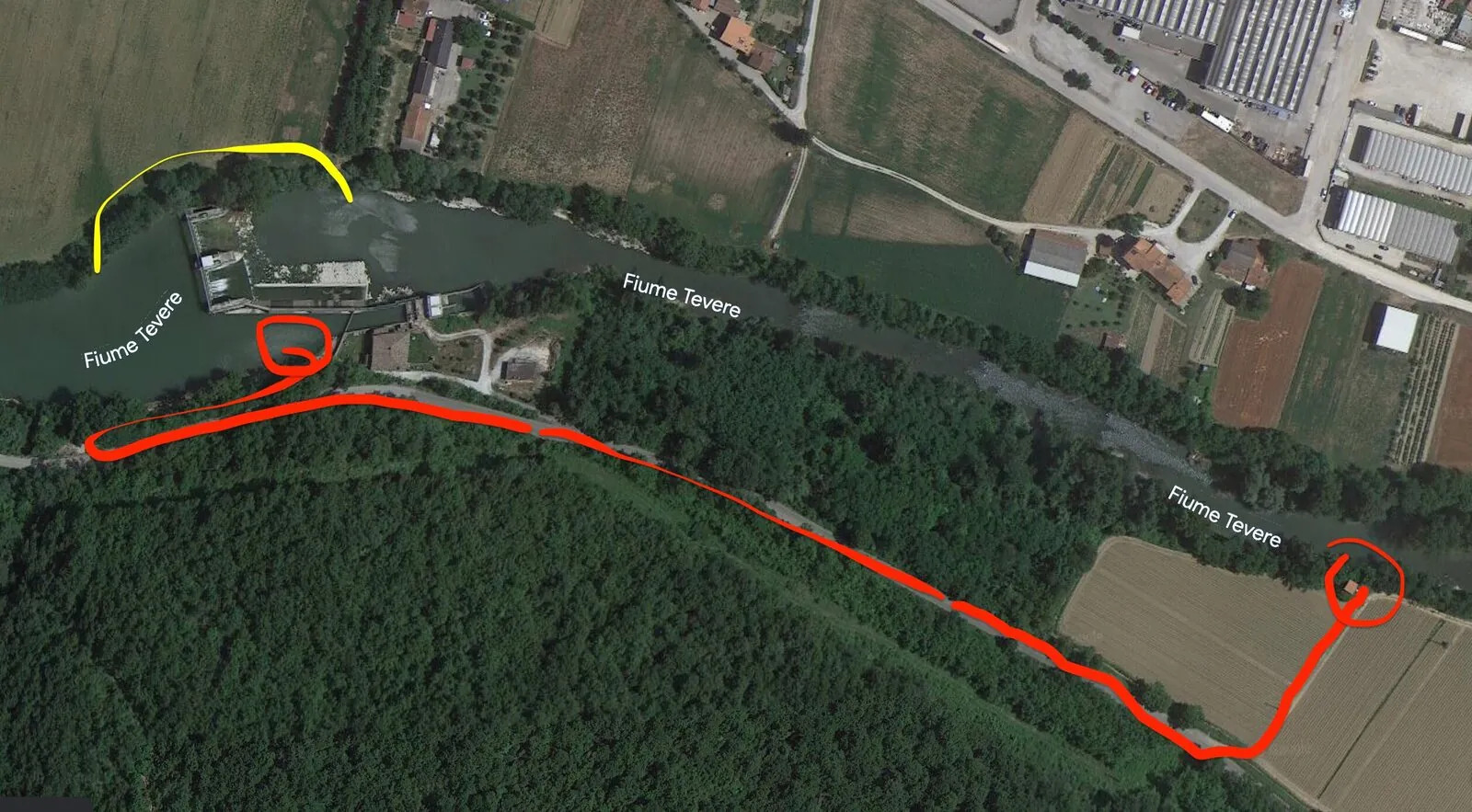
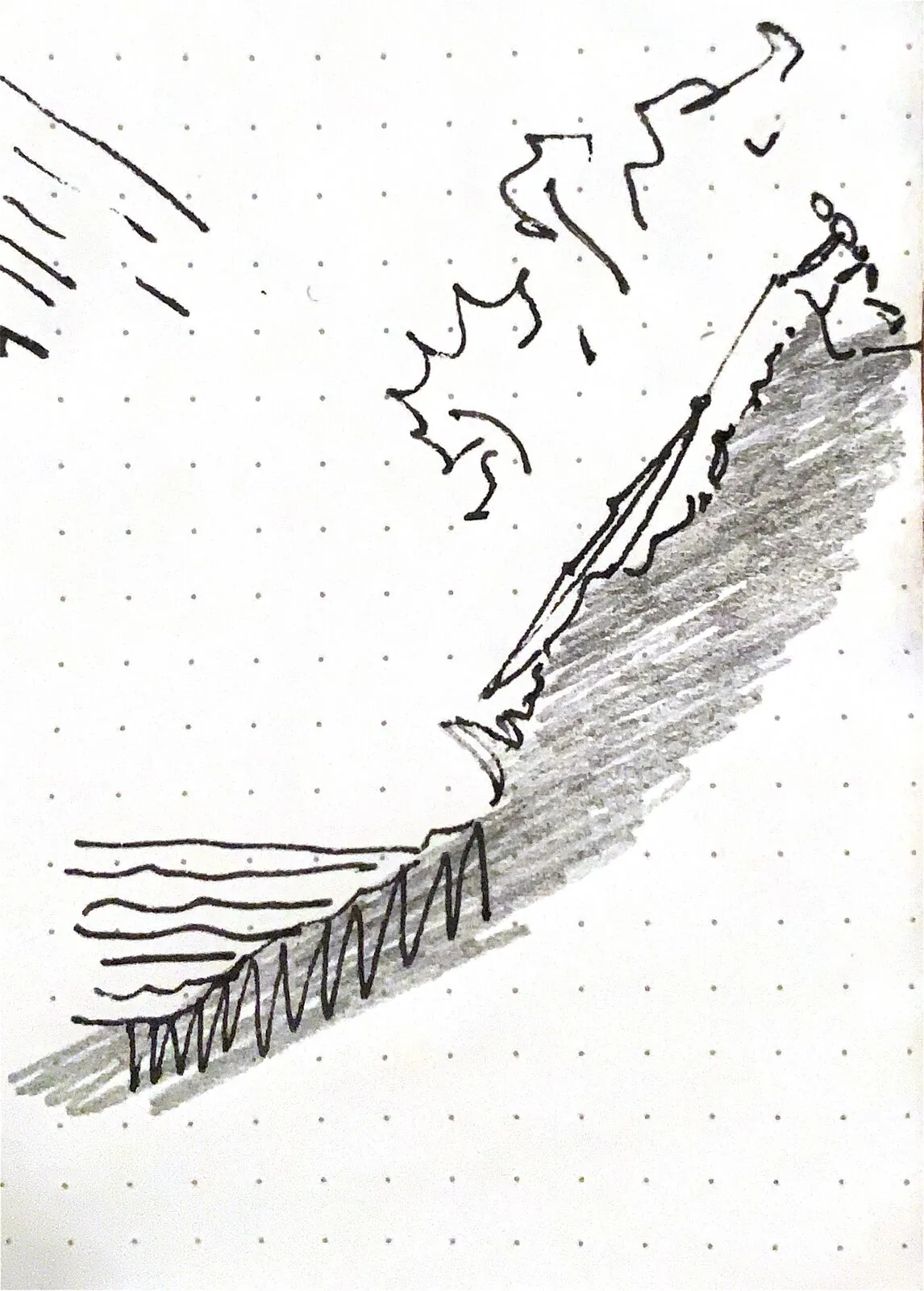
Then came Umbertide, where the backwater of the next dam could already be felt. At the dam I took the canoe out on the right side, at the power station, and because it was fenced off I had to walk a long way until I found a place where the river could be reached. I cannot recommend the place where I carried the canoe back into the water at all. There is a height difference of 8 to 9 m between field and river, steep and overgrown with every kind of plant. I lowered the canoe down the slope with straps, without straps this manoeuvre is not possible. And then I climbed down myself.
Portage at the Umbertide dam: about 5 km of backwater up to Umbertide. Before Umbertide a rock weir, portage on the right. 2 to 3 km later the Umbertide dam. Unlike me, I recommend getting out on the left. On the right, access to the river is very difficult.
After that I paddled on through a beautiful stretch with many rapids, until I reached a gravel island at around 18:00. There was a thunderstorm in the night.
Day 5 · Ponte Pattoli to San Martino in Campo, 25 km
The next morning was extremely cold as usual. I am not properly equipped for the conditions, and the low temperatures were really getting to me. My sleeping bag is made for 5 degrees, but the nights are so cold that I sleep fully dressed: ski underwear, T-shirt, jumper, jacket, scarf and hat, and I still freeze.
The next kilometres were backwater up to the Villa Pitignano dam, where I lifted the canoe over the crest of the dam, which saved me a long portage.
In the next few kilometres you have to keep a lookout, some places are hard to get through by canoe. One place is just before the bridge at Ponte Felcino, in my case the water level here was high enough to paddle it. You have to be careful especially at Pretola, because the remains of the bridge at Torre di Pretola make it difficult to get through. In my case there was little water, but on the left side there was a line that could be paddled. After Ponte Vallecepi there are also stones in the water, keep a lookout.
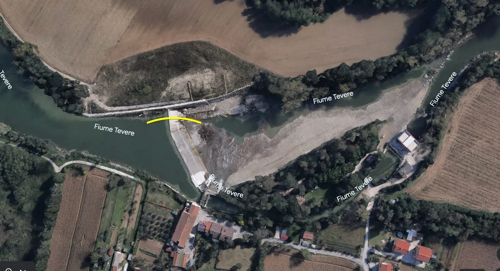
Up to Ponte San Giovanni there is again a very long backwater, so no current. At the dam I took out on the left, because there is a Lidl right by the river. Once I had supplies again and had patched the wheel of my luggage trolley, I carried the canoe over Ponte Nuovo Vecchio and then on the right bank back into the water over ruins and thicket.
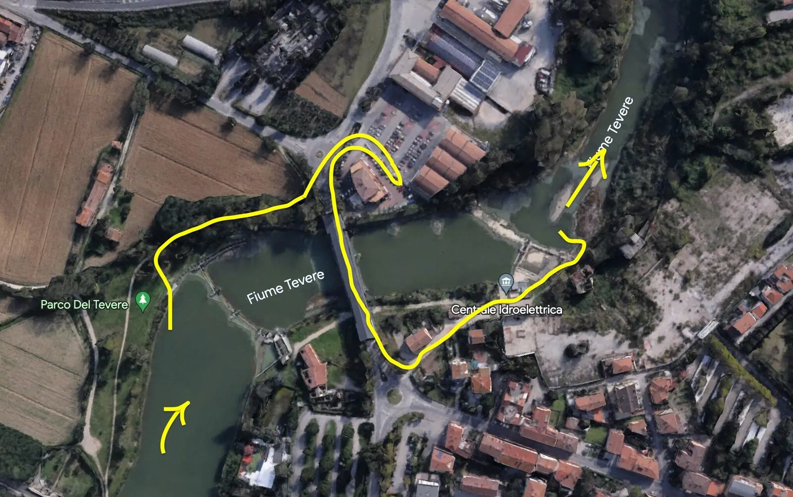
After that the river runs fairly straight for a long time, only at the second bridge after Ponte San Giovanni, at Romano di Sotto, is there a rapid that cannot be paddled at some water levels and that had a very bad line when I paddled it. Definitely stop briefly and take a closer look at it.
While looking for wood I found the carcass of a dog quite close by. So one side of the gravel bar smelled strongly of rot, but the wind was blowing in my favour.
Day 6 · San Martino in Campo to Montemolino, 41 km
Unbelievable cold early in the morning. The sun only reaches the river late and at this time of year is mostly too low to shine through the vegetation. The result is that the rivers are mostly a few degrees colder than the normal surroundings.
I only start paddling at around 11, but after less than an hour I have to stop to patch my canoe. The canoe is extremely damaged and full of cracks, a lot of water seeps in.
At Ponte Nuovo there is a place under the bridge that cannot be paddled, because fast shallow water and big stones make it impossible. I was able to float the canoe through on the left. What follows is many kilometres without obstacles, where the Tiber slowly meanders through Umbria.
Here I used a 40/10 system for the first time, which I can recommend: paddle for 40 minutes without breaks and then rest for 10 minutes, very effective.
Portage at the Montemolino dam: Careful, slippery. The whole dam wall is covered in slimy algae that you easily slip on, as I did. Depending on the water level it may be wiser to take the canoe out on the bank and only put it back in later.
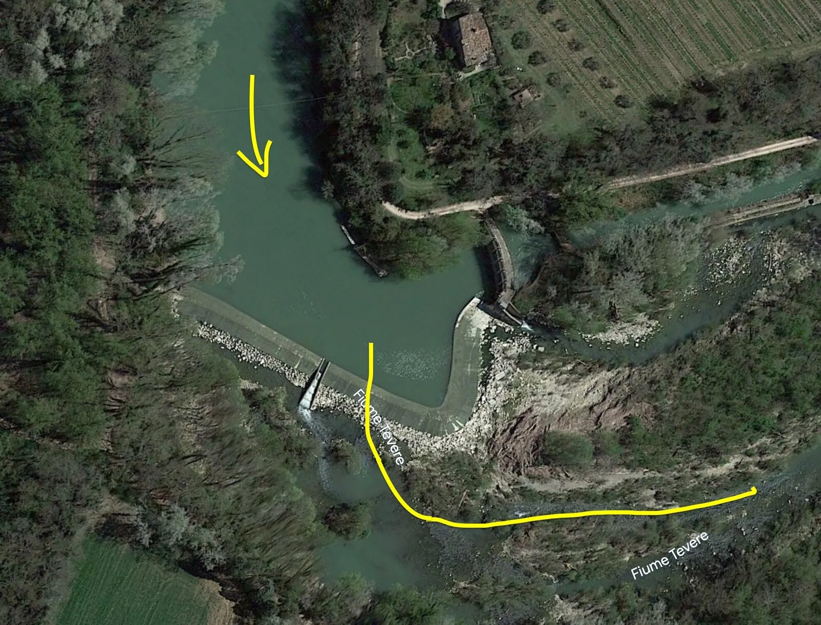
For the following kilometres the river has little water, because it is diverted and fed back later. So for a good stretch here you have to float and push the canoe. This section had extremely little current, especially the 15 km before Montemolino are down to muscle power.
Day 7 · Montemolino to Lago di Corbara, 22 km
Slept extremely badly today, my body is exhausted from the bad sleep, the hard conditions and the bad food. In Pontecuti I stopped briefly to fill up with water and in the hope of finally finding something decent to eat. For the last few days I have eaten nothing but bread, snacks, bad pasta and tinned food. I found no food.
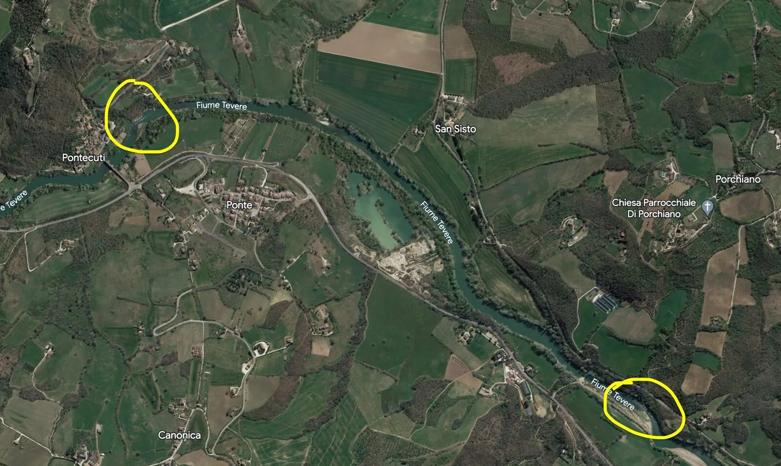
What followed I had not expected at all. In the distance I saw big waves, about 1.5 m or higher, but decided against taking a close look at the rapids. I had promised myself a rest day at Lago di Corbara, and there were only a few kilometres left. I just wanted to get there. So I put on the GoPro and trusted my skills.
So with the heavily loaded, damaged canoe an exhausted and hungry Tassilo paddled into grade III white water. Later I realised that the cracks in the canoe had made the area under the seat extremely wobbly, so I could no longer handle turbulent water well either, since balancing was now impossible.
I just about fought my way through the first waves, but at the last wave the current was too strong and it pulled me in. Suddenly my head was under water. I remember thinking: will I get out of here? You have to imagine that I had removed all the canoe's safety features, the air bags at the front and back, to distribute the luggage better. I was sitting firmly wedged in the canoe, with a bag between my legs, full water bottles against my thighs, a spray deck on top and a bamboo pole over that. I had no helmet and no life jacket with me. So the question was justified.
I only just managed to tear myself out of the canoe, and turned the canoe over just in time, before it was too full of water. The river had torn the GoPro off my head, and so I put all my hope in the canoe. The backflow began to pull me towards the wave again, the current was strong and I did not have much time. Kicking, I fought my way against the current towards the bank, and was incredibly lucky, because I was able to pull myself onto a branch and so save the canoe and myself.
As always, there was nobody anywhere who could have helped me.
I was on the point of simply jumping into the ice cold water to look for the GoPro. Thank God I did not, the temperature and the currents alone would have finished me off. Instead I worked out a system: I tied a heavy stone to a floating object, with 6 metres of cord, and threw it into the water from the canoe to find out how deep the river was. The stone did not touch the bottom, it was always more than 6 m. So I knew the GoPro was lost.
About the stretch: From Montemolino to Pontecuti a steady current of about 2 km/h, then come the two rapids, which get so high because two rock slabs leave the water little room to flow through. Shortly after the first comes a similar one, also grade III, which should only be paddled with a lot of experience, the right gear and in company. The next kilometres up to the reservoir have no current. Up to Lago di Corbara you will always find enough driftwood for a fire on the Tiber, but on the stretch after that, not any more.
Day 8 · Departure
The next morning I got out of the tent early to light a fire and so escape the cold. On one of my trips to look for firewood I found a big antler. After the long night I had decided to pause the expedition, and it almost seemed as if a stag's crown was my reward for my many sacrifices.
At around 14:00 I had packed everything and set off towards Corbara. It was maybe 3 km to the opposite bank, where I landed and hid my canoe in the thicket and half buried it. From there I had to walk a long way, loaded with three bags, tent, pot and antler, along the lake to Corbara and then towards Orvieto. After a few hours of walking, hitchhiking worked. In Orvieto I first ate and then took a train to Rome. At 9 I was in Rome. A week earlier I had set off.
Second stage
Day 1 · Journey there
At around 20:00, after half a day in Orvieto, I walk towards Corbara with my thumb out. Hitchhiking works brilliantly, three people give me lifts, I am at Lago di Corbara shortly after sunset and still have to walk 45 minutes to the canoe. It was still there.
Day 2 · Lago di Corbara to Alviano, 22 km
Slept well, good temperatures in the morning. It is raining again, and I wait out the wet in the tent. When the rain stops for a moment, I pack up and set off. A storm is coming, and there is tremendous thunder, so I take the canoe out of the water earlier than planned, on the right side of the lake. I push the canoe on a trolley that is broken once again a few kilometres further, to just past the dam.
During the preparations the dam keeper comes past and was quite shocked when I told him about my plan. Luckily he saw me, because if he had decided to open the dam that day, it would have been incredibly dangerous. Be careful.
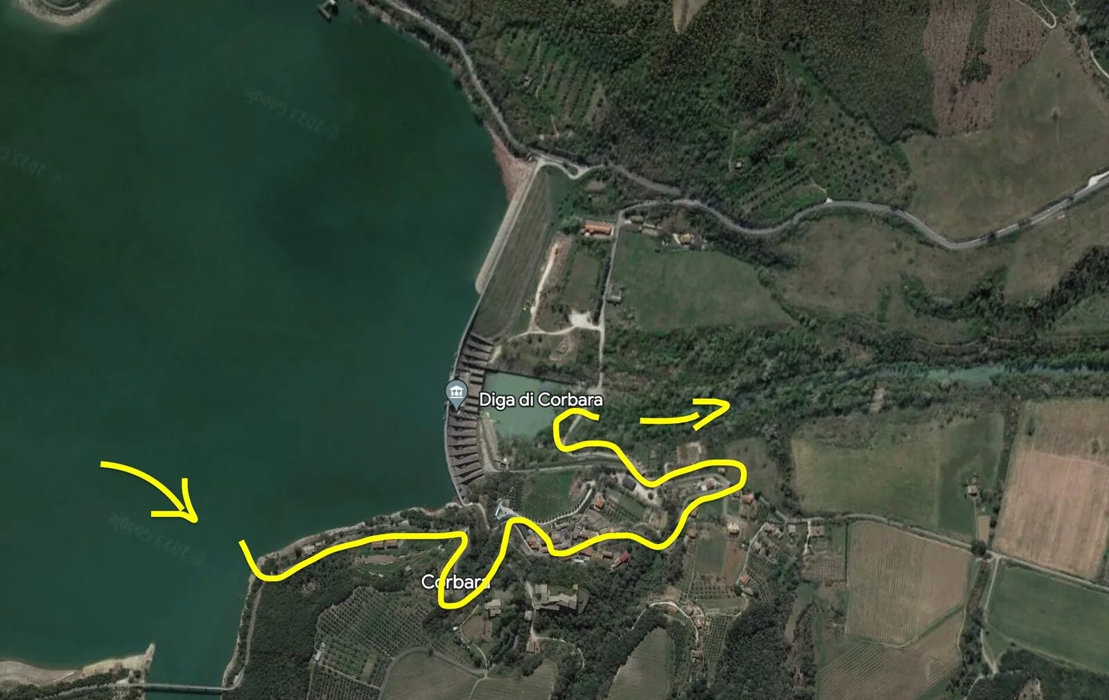
The next 10 km or so are very beautiful, but the river has extremely little water, because it is pumped through the power station. So you often have to get out to guide the canoe past rapids. In some places you have to make awkward climbing moves, and in others really risky passages through big rocky rapids, where you get wet up to the hips or more. If possible, do this stretch in a pair or more, because a wrong step or a foot caught in the dark water easily turns into an accident.
At around 2 or 3 I was at Baschi and climbed up the steep slope on wild boar paths under the motorway, because I had no water. Access to the village is very tiresome, I would rather recommend getting out a bit earlier. For the next few dozen kilometres there will be no more chances to get anything near the river.
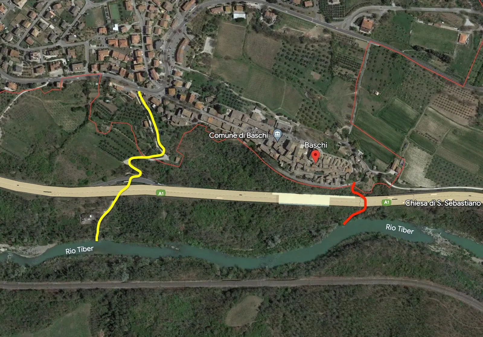
Day 3 · Alviano to Ocriculum, 35 km
In the morning, repairing the canoe again. When I was ready to go at around 9 and wanted to put the canoe in the water right at the dam, the dam was suddenly opened. Within a few minutes the water level had risen by several metres, and big waves formed in the river. To avoid them, I carried the canoe a few hundred metres further. The current was now strong and the river very wide, so I made fast progress.
I stopped briefly at Porto Romano di Seripola, a beautiful Roman excavation site. It is practically abandoned, and the roofs are falling apart. I went on in the rain to Orte, where I arrived at 2. The town is worth a visit, sitting high on a hill it has very beautiful buildings and great views. Somehow I also got into the underground city, where I explored alone for a long time. Very much worth seeing.
Back at the canoe I paddled until 19:30, as far as Ocriculum, an old Roman town of which some ruins still stand between the fields. I explored here until it got dark, it is really incredible, with huge halls and half buried passages. In the dark I then carried everything to the amphitheatre, where I spent the night.
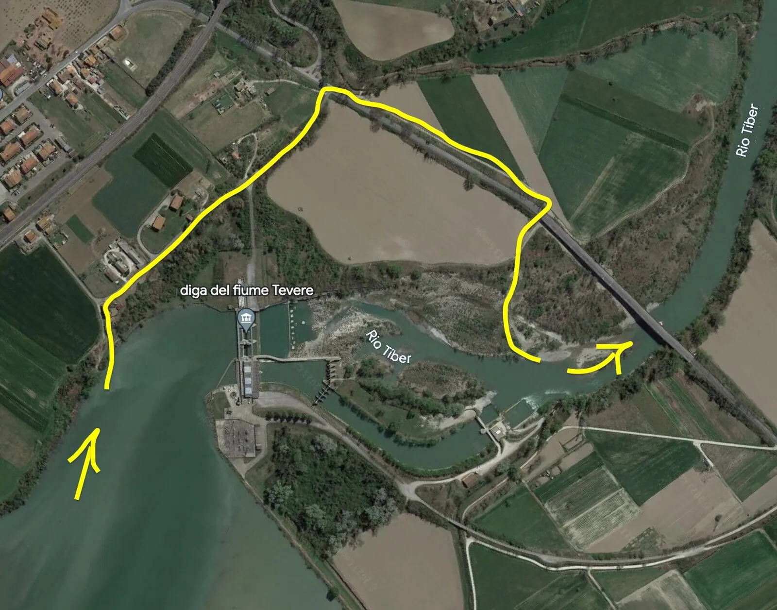
Day 4 · Ocriculum to Stimigliano Scalo, 30 km
A few kilometres later a dam came in my way. This dam is a double dam, but it still has an arm of the Tiber that carries little water. I thought it would be easier to walk a bit with the canoe, so I took the canoe out on the right bank and in the end walked 4 km through the countryside with the canoe. The trolley is broken again. So in total the portage took 3 to 4 hours.
Portage at the Scalo Teverina dam: I can only recommend taking out on the right and paddling on in the arm of the Tiber, there should be enough water flowing. Otherwise there are no good put in spots anywhere, and everything is harder than paddling. The easiest part of canoe touring is always the paddling.
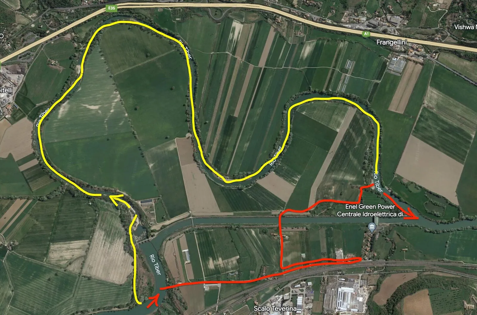
Fairly soon after comes Ponte Felice, where there are big waves under the bridge that can actually be paddled with a canoe. Since mine was so broken, I decided against it and pushed it through on the right, where there was less current. After that I made another stop at Torre dei Giacanti, where the ruins of an old castle stand on the hill, and there is a great cave.
Day 5 · Stimigliano Scalo to the Nazzano dam, 27 km
The canoe is in a miserable state, and many of my clothes, almost all of them really, are wet. I decided to take the morning to dry my clothes, and walked a few kilometres to the nearest village, Stimigliano Scalo, to buy supplies and duct tape. There were hardly any places on the canoe without cracks or holes.
Again very little current, the kilometres before Rome consist of one backwater after another. Shortly after Poggio Mirteto Scalo there is a film set built by the river, which I had a look at and climbed.
Portage at the Nazzano dam: Before Nazzano many kilometres with no current. Nature reserve, do not make noise. The jetty of the park house is well suited for taking out, it is the only good place. Once again it is a double dam.
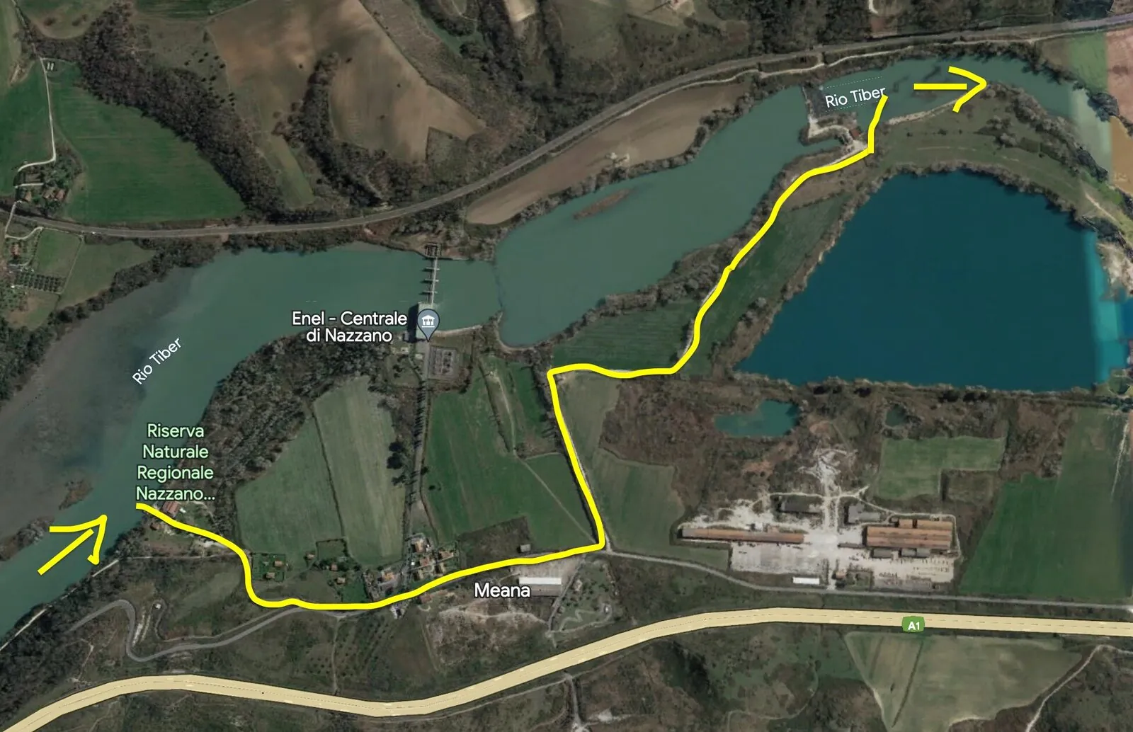
Day 6 · Nazzano dam to Settebagni, 34 km
The next morning a guard, armed with a stick, came by and asked what I was doing here. I assured him I would leave soon, which I then did at around 9:30. My hope for current was in vain, because there was almost none at all, 1 to 2 km/h at most. I camp once just before the city of Rome and tomorrow just after it, because camping in a city is never ideal.
Day 7 · Settebagni to Stazione Magliana, 39 km
At around 11:20 I was at the dam at the Grande Raccordo Anulare. I climbed out on the right into the power station and once again had to note how badly power plants in Italy are guarded. I found no good way out on the site and paddled back less than 100 m until I came to private property. As I was lifting all my stuff over, a fisherman came and asked me gruffly what I was doing there. I told him that I had not seen any other place to get out, and he helped me lift the canoe over the fence and recommended a way to the river.
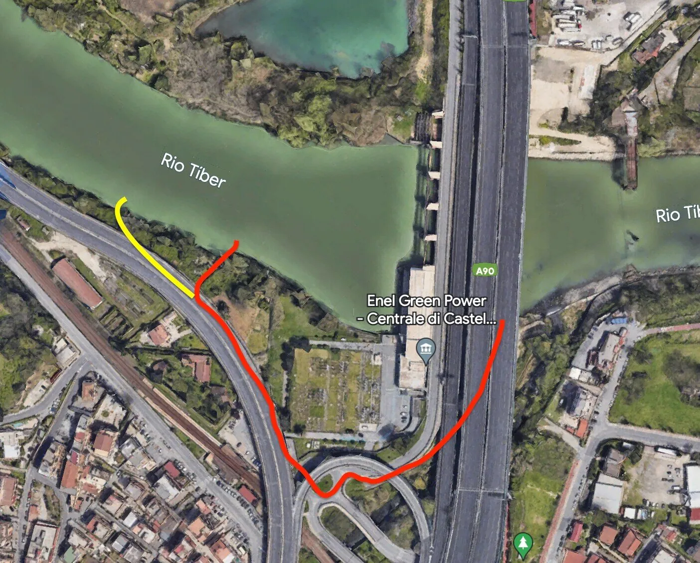
On I went, with little current, through river landscape, here too nobody to be seen anywhere, although in theory already in Rome. Many kilometres later I pass the confluence with the Aniene, from here on I know the Tiber. Shortly after, Ponte Milvio, where there were big waves, of which I did the first part. The rest was too risky for me, after all the damage my canoe was too unstable for water like that. The waves can normally be paddled well, but definitely get out and look, because the second part is very shallow at low water.
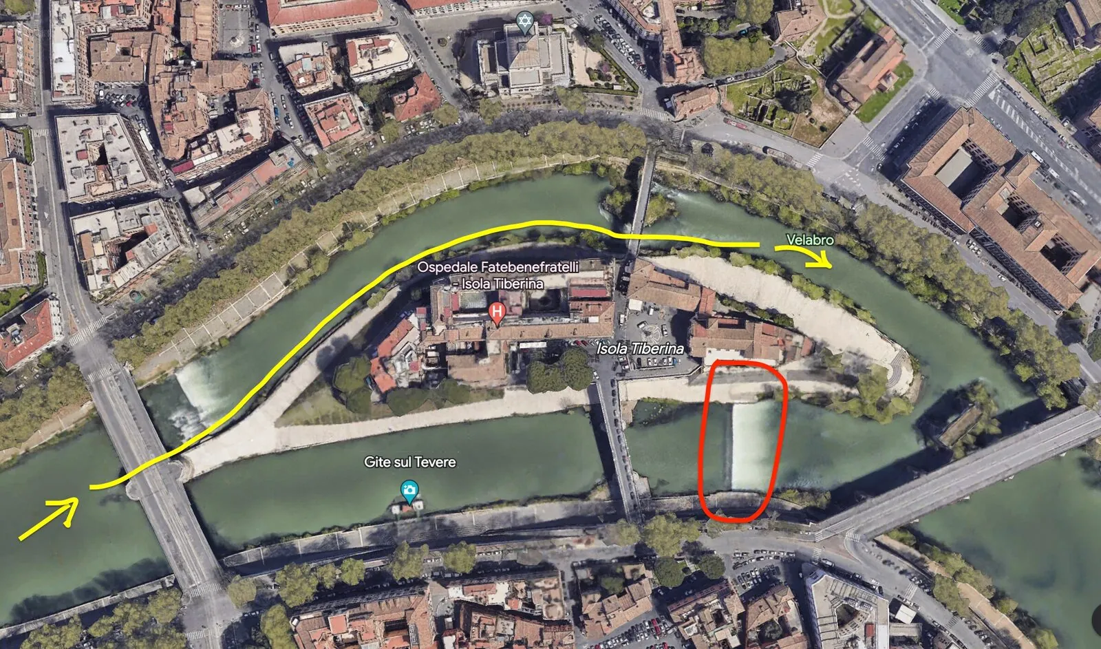
Isola Tiberina: At the island in the Tiber you absolutely have to keep to the left, because on the right there is a very dangerous stopper. On the left you can get through depending on the water level, it is best to look at the line beforehand. The second rapid is much more dubious and can have very high waves. Otherwise portage on the left.
At 19:00 I passed two cars that the Mafia had probably driven into the water.
Day 8 · Stazione Magliana to Porto di Ostia, 30 km
At around 11:00 I was at the turn off to the canal of Fiumicino, which the Roman emperors had built, and followed it to look at the old Roman harbours. Impressive structures, some buildings have not yet been explored. The church by the river is also very beautiful.
After a few hours back to the canoe, paddle back along the canal and on to Ostia Antica. Tied up the canoe and looked at the excavations, which are really worth it and beautiful. An extremely well preserved Roman town. To the north is the papal castle with a medieval village and a very good pizzeria.
A storm was approaching, so at around 17:40 I covered the last kilometres to the sea. At last I had arrived. After that I did the last kilometres to Porto di Ostia. At 19:15 I made the last paddle strokes and finished a trip that had taken me 380 km through central Italy to the sea.
I was very tired, but there was still a long way home. First I had to bring the canoe to the station in Ostia, so many kilometres of walking, then sneak into the station and then persuade the train driver to take me. There I sat in the train with my 4 m long canoe. And then again many kilometres on foot, from the station right across the city. I arrived completely wiped out at midnight.
The long journey was over.
I can recommend a descent of the Tiber to anyone.
Packing list
| Clothes | Tech | Other | Food |
|---|---|---|---|
| 3x T-shirts 3x jumpers 2x long trousers 1x swimming trunks 3x underwear 1x ski underwear 1x jacket 1x rain jacket 1x beanie 1x scarf 1x hat 1 pair of trainers 1 pair of ski socks |
3x power banks GoPro with accessories Drone with accessories SD cards Chargers and cables 2x torch 1x head torch 1x watch |
2x lighter 1x gas stove 1x cooking pot 1x cloth 1x fishing gear 2x duct tape 1x sun cream 1x toiletries 1x soap 1x cord 1x tent 1x sleeping bag 1x notebook 2x pens 1x waterproof phone case 1x knife 1x water quality test kit 1x canoe 1x paddle 1x cover 1x canoe trolley 6x 3 m straps |
16x muesli bars 2x protein bars 2 bars of dark chocolate 1 kg rye bread 2x peas (tins) 2x ceci (tins) 2x beans (tins) 1 kg almonds 1 kg dried apricots 1 kg oats 1 kg peanuts 1 kg raisins 1 kg dates 1 kg pasta 1x tomato sauce 1x pesto 1x anchovies 2x jam 6x apples |
This report comes with annotated aerial images of the portages at the dams of Umbertide, Villa Pitignano, Ponte San Giovanni, Montemolino, Corbara, Alviano, Scalo Teverina, Nazzano and the Grande Raccordo Anulare, with the recommended and not recommended routes drawn in. Anyone who wants to paddle the Tiber and needs them, just write to me.
Download the full report as a PDF (in German) Befahrung des Tibers · 20 pages, with all maps and portages · 8 MBMeant to take with you on the water: on the Tiber there are stretches with no signal.